
Bird licence applications: count fish-eating birds on a river
You must record variability in bird numbers and behaviour the year before you want to kill birds to conserve Atlantic salmon or sea trout.
This is to help understand:
- the distribution of birds over time
- where the greatest the impact may be occurring at a particular site

Decide where you will carry out counts
Choose sections of rivers that are no more than five kilometres long. These sections of rivers are called control sectors.
A control sector will have an start and an end point marked by ten figure national grid reference.
You can apply for a licence for a single control sector or multiple control sectors on one river.
Give each control sector a reference
xxxx
Create a map of your control sectors
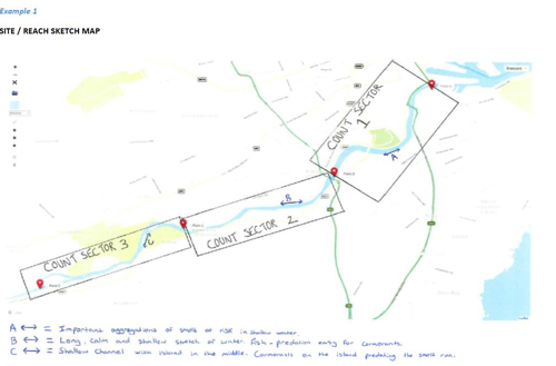
Your map or sketch must:
- identify each control sector - create your own reference
- record the six figure national grid references at the start and end point of each control sector
- identify important fish areas, for example the smolt runs - this information is very important to understand potential conflict at a critical stage of the fish life cycle.
You must upload the map to your licence application, with your completed count.
When to count
Carry out counts during those months when you wish to shoot birds, and at the time of year that damage occurs.
Counting method
You must survey all control sectors.
Carry out counts before you use any scaring activities.
Make several visits to the same site on different days, at different times of day. Keep repeat visits to the same site at least three days apart.
Use the same recorder and the same reporting method.
Survey multiple control sectors on the same day to reduce the risk of double counting birds that may move between control sectors.
If you are counting multiple control sectors you can count as many as you like on the same day, since each sector will be a different ‘site’ for recording purposes.
Ideally, the whole length of control sectors could be counted in one day in a co-ordinated effort.
Count birds that arrive into or leave the site during your count unless you are walking a stretch of linear water (river reach) and they fly over your head and go in ahead of you – in this case you will see these birds again later in the survey and they should not be double-counted.
How to record the count
At each count you must record:
- Control sector number
- Start point grid reference
- End point grid reference
- Date of count
- Start time
- Species of fish-eating bird
- Numbers of each fish-eating bird counted
- Behaviour of each fish-eating bird
Enter your count information
You must upload your completed count and your map or sketch to your licence application.
Upload your map